|
L'extrait
ci-dessous d'une revue amťricaine de gťologie,
prťsente un mťmoire exposť dŤs la fin de la guerre
sur l'intťrÍt de la gťologie pour de nombreux usages
tactiques : rťserves d'eau, ťclatement des obus,
tranchťes, etc. Dans la partie concernant les manoeuvres, notamment celles des chars, l'exemple
donnť est une trŤs intťressante carte gťologique du
secteur est de Bl‚mont.
SHORTER CONTRIBUTIONS TO GENERAL GEOLOGY, 1920.
THE USE OF GEOLOGY ON THE WESTERN FRONT
By ALFRED H. BROOKS.
(Presented in abstract before the
Geological Society of America Dec. 31, 1919)
[...]
MANEUVERING.
The influence of swamps and marshes on strategy and
tactics is of course well established. On many
occasions skillful leaders have defeated an opponent
by taking advantage of impassable ground. Present
tactics and modern equipment in artillery and tanks
have led to a revision of the old classification of
passable and impassable ground for troop maneuvers.
This revision has been necessary because of the
colossal scale of modern operations, involving not
only tremendous .concentrations of men but also
enormous unit weight of mobile equipment, such as
artillery and tanks. A land surface that would have
been no obstacle to maneuvers in former wars, with
their relatively small numbers of troops and light
equipment, might prove almost impassable for the
great bodies of men and the heavy equipment demanded
by present tactics. There were, of course, plenty of
exceptions to the new requirements during the late
war, for much fighting was done in swampy lowland
and even among rugged snow-clad ranges, where the
great concentration of infantry in attack and the
use of heavy equipment was impossible. The decisive
battles of the war, however, were fought in areas
where the passability of the ground was an important
element. The question whether a certain hill slope
is made up of slippery clay or of hard ground may be
the decisive factor in a tactical movement. Again,
the success of an operation may hinge on the quick
traverse of a certain valley bottom. If the valley
floor is silt or clay, it will be soft and muddy
during the wet season and difficult to traverse; if
it is sand and gravel it will be hard and dry and
easy . of passage by troops and equipment. Again,
the successful fording of a stream may depend on the
physical character of the stream bottom. A knowledge
of the geology of the region will make it possible
to forecast the physical conditions of the surface,
and this will often be of immense service in
formulating plans for tactical movements.
The feasibility of a maneuver depends, as shown
above, on the physical condition of the soil, as
well as on the topography. Complete understanding of
the topography of the scene of operations is clearly
of first importance to the tactician. It has been
emphasized in many publications, notably by the
French, that a thorough knowledge of military
topography can best be obtained by understanding its
relations to the bedrock geology and to the recent
geologic history of the region. This subject relates
to the training of officers and, though important,
need not be further discussed here. The influence of
topography on tactical movements has, however, been
emphasized to the exclusion of almost any
consideration of the effect of soil conditions. An
escarpment may afford an admirable defensive
position, but a lowland underlain by clay may during
a wet season be even a still greater obstacle to an
attack. Ground that could be readily traversed by a
light skirmish line might, after being crossed by
repeated waves of infantry, be so churned up as to
become practically impassable for rapid forward
movement. Even if passable by infantry it might be
impassable for artillery and tanks.
Another aspect of the problem is the effect of
modern artillery fire, with its penetration in
unconsolidated material to a depth of nearly feet. A
barrage may so churn up the ground as to make it a
serious obstacle to rapid infantry attacks and
impassable to heavy equipment. It is evident that
the shell craters will be much larger in
unconsolidated material than in hard rock, and which
kind of ground will be reached by the shell fire can
be determined in advance by the use of geology.
Moreover, underground conditions may lead to the
shell craters being filled with water from below and
thus add still greater obstacles to advance.
The location of outcrops of hard, brittle rock
within the enemy lines, especially in their
fieldworks, may also be of some local importance.
Artillery fire that hit such outcrops was more
effective because of the splintering of the rocks.
Whether ground will be hard or soft at any
particular time depends principally on the physical
character of the soil and subsoil and on the amount
of precipitation. Therefore the determination of the
physical conditions of the surface as a guide to
planning troop maneuvers involves the use of data on
geologic conditions and rainfall. .A knowledge of
the areal geology is of first importance, and hence
a geologic map is indispensable.
The lithology of the formations immediately
underlying the surface must be known, as well as
their products of weathering including soil and
subsoil. An essential element to the problem is the
depth to hard rock, for obviously if bedrock occurs
near the surface, with only a thin cover of soil,
the ground will be dry and hard at all seasons. On
the other hand, if there is a heavy cover of soil
and subsoil that have certain physical properties
.the ground will become soft and water soaked during
the wet season. If the surficial material is
pervious, as, for example, in a sandy soil, the rain
water will soak deep into the ground and the surface
will remain dry and hard, but where there is an
impervious surficial deposit, such as clay, it will
hold the water and form soft, muddy ground. Other
geologic factors, such as depth of ground-water
table and degree of saturation of soil and subsoil
at the time of rainfall, also affect the problem.
The dip of the strata determines in a large measure
the areal distribution of the formations and this of
course holds true of the soils derived from them. In
areas of horizontal strata there will evidently be
less variation in type of soil from place to place
than in regions of close folding.
In the practical application of these principles no
great refinement will be necessary. Having a
geologic map of an area with which he is familiar
and data on precipitation, an experienced geologist
will be able to forecast the soil conditions of any
formation with a sufficient degree of accuracy for
use in maneuvers.
The whole problem is closely tied to the quantity
and seasonal distribution of rainfall. A certain
formation may afford hard footing and hence be
easily passable during the dry season, only to
become soft and practically impassable during wet
weather. Therefore monthly data on precipitation are
absolutely essential, and information about
evaporation is desirable. In northern latitudes the
seasonal distribution of ground frost may have a
bearing on the passability of the terrane at times.
The permanent ground frost of polar and subpolar
regions introduces another element. In these regions
the soil and subsoil thaw only to a depth of 1 foot
to 3 feet during the short summer. This condition
produces a swampy character in the ground even on
hill slopes, and as a result much of the country is
almost impassable for modern armies.
An area in which the character of the soil and the
precipitation are such as to form muddy ground
during the wet season may be artificially drained.
Locally the plain of Flanders has been so drained as
to give relatively hard ground, but the great plain
of western Russia, with similar natural physical
conditions but not drained, is wet and muddy.
In arid and semiarid regions the considerations
above set forth are. of less importance, for the
terrane, except for talus slopes, is likely to be
firm at all seasons. As the greatest concentrations
of the population of the world are in the humid
regions, however, these are likely to continue to be
the scenes of important wars. Therefore the use of
geologic maps in forecasting the physical conditions
of the surface of the ground deserves attention by
tactical leaders. This military use of geology need
not be overemphasized, for evidently in many regions
it will have little practical application. Moreover,
its important effect in military maneuvers will be
confined chiefly to the wet season of the year.
Though geologic maps may be only occasionally of
service to the tactician, yet he can not afford to
ignore any source of information about the physical
character of the terrane in the scene of his
operations. Advance knowledge that the soil
conditions in this or that part of the battlefield
will slow down an infantry attack or make the
advance of artillery or tanks impossible may give a
decisive advantage in a given movement. Some
instances from the late war, showing the influence
of geology on troop maneuvers, can be cited.
In the Lorraine sector of northeastern France
strongly contrasting physical conditions were found
between the areas underlain by hard limestones (Jurassic)
and sandstones (Triassic) and those underlain by
clays and marls (Liassic and Jurassic). The former
afford hard footing at all times; the latter during
the wet season were in many places impassable for
heavy equipment, such as artillery and tanks or even
for quick movements of large bodies of infantry. The
wet country may be provided with hard roads, but in
time of advance the enemy will destroy the roads in
whole or in part, so that they are likely to be
impassable. Moreover, a general attack is made over
a broad front, and the advance of heavy artillery or
tanks must be possible without counting on the use
of roads.
The Germans had planned their withdrawal from the
St. Mihiel salient in October, when the water-soaked
clays of the Woevre lowland are in their worst state
so far as the movement of troops is concerned.
Captured documents showed that they had formulated
very elaborate plans for the demolition of roads and
bridges. Fortunately, our attack. was made in
September, both before the physical conditions were
at their worst and before the plans for demolition
could be accomplished. Had the attack been deferred
until October and the roads been destroyed as
planned, a part of the new positions would have been
almost impregnable to attack until after the rainy
season. Evidently the Germans had taken into account
the physical conditions of the surface formation and
its seasonal variations.
The physical character of river bottoms and banks
may also be an important factor in carrying out any
particular movement. A shallow watercourse bottomed
by mud or silt will be impassable for large bodies
of infantry, not to mention artillery and tanks. The
presence of a bedrock reef on such a stream,
affording a hard bottom, will provide a feasible
crossing. For example, the streams traversing the
Woevre lowlands, underlain by the Oxfordian clay
shales, had muddy bottoms that could not be crossed
by artillery, tanks, or large bodies of infantry. In
places, however, as shown by the geologic maps, the
streams traversed limestone reefs where crossings
could be made. Geologic information of this kind was
used in the planning of the St. Mihiel attack,
principally in choosing routes for tanks. Again, the
gravel-filled valleys of the streams whose sources
are in the hard rocks of the Vosges Mountains afford
dry, firm footing, but the Meuse and its tributaries,
traversing areas of soft limestones and shales, are
bottomed with silt and mud and are very difficult to
traverse during the wet season. The ground underlain
by the Cretaceous chalk usually remained hard during
all seasons. Many of the Tertiary formations became
water soaked during the wet season and furnished a
difficult terrain for troop movements. Much the
larger part of the success in the use of tanks
during the war was attained in the chalk areas, but
attempts to take tanks across areas underlain by
clay formations, such as the Oxfordian, in the St.
Mihiel salient, failed.
The study of the physical conditions affecting troop
movements must sometimes take account of the effect
of barrage fire. In the Tertiary formations of the
British front there were places where an artesian
water-bearing sand was capped by impervious clay. As
a result of a heavy barrage the ground was pitted
with innumerable shell craters filled with water
from the underlying strata. Advance over such ground
was exceedingly difficult for infantry. The
designation of the areas where these conditions
existed, so that they might not be chosen as scenes
of attack, was one of the duties of the British
geologists. On the other hand, where an impervious
clay overlay a dry sand the effect of shell fire was
to drain the surface. Such types of terrain might be
of local importance in affording a series of dry
shell craters to organize as defensive positions.
The use of geologic maps to forecast the physical
conditions of the surface was of slow development
during the war. In this field the French did the
pioneer work. A map of a part of the Reims sector,
making a classification of surface deposits
according to degree of passability, was issued by
the Fifth French Army in July, 1917. It is called a
soil map and is on a hachured base on a Scale of
1:80,000. The physical character of the surface outcrop of each formation in its relation to
infantry and artillery movements is described for
both the wet and dry seasons. This appears to have
been the first and probably was the best of this
type of geologic maps. The French also issued "general
information maps," on some of which the soil was
outlined and classified in a crude way according to
passability. Toward the end of the war the Service
geographique started on a project to make a series
of maps for the use of tanks, but none of these were
issued.
As has been shown, the British geologists were
consulted on questions relating to physical
conditions of the surface, especially in regard to
the effect of barrage fire. They also prepared some
maps, giving a broad classification of their entire
front with reference to the use of tanks.
No special maps giving a classification of soils as
affecting the maneuvering of troops were issued by
the American Expeditionary Force. Information of
this kind was, however, given on some of the
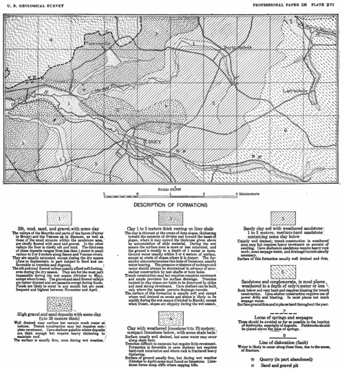
geologic engineering maps. In these the explanations
included a description of the surface conditions of
each formation for both the wet and dry season. An
example of this type of map, the original of which
was in colors, is given in Plate XVI.
It also fell to the geologists of the American
Expeditionary Force to collect and make available
information about river crossings. This had largely
to do with the fluctuations of stream volume but
also took into account the character of the river
bottom. The description of the topography and
geology of the enemy's lines, prepared by the
geologists of the American Expeditionary Force,
included mention of the areas in which hard or soft
footing would be found on the uplands and slopes as
well as in the valley bottoms. Just before the
armistice the Tank Corps of the American
Expeditionary Force developed a plan to make use of
a geologist in the selection of area suitable to the
maneuvering of tanks. By that time experience had
shown that a proper use of tanks is possible only if
heed is given to the physical conditions of the soil.
It appears that in the German Army the use of
geology in forecasting the conditions to be
encountered in an advance was only a late
development. Not much space is devoted to this
application of the science in the German secret
manual of war geology published in January, 1918.
Through the courtesy of Dr. A. Renier I saw at
Brussels a German map giving information of this
type, issued in June, 1918. This was called a
military geologic map and is published on a scale of
1:50,000. The legend is of the same general type as
those of the French and American maps already
described. Its purpose is evidently to guide the
tactical commander in planning a forward movement.
While intended primarily to describe the surface
formations, it also contains geologic information
bearing on fieldworks. The areas of natural and
possibly artificial inundation are indicated. Like
all the other German military geologic publications,
the map is confusing because of the attempt to show
too great a variety of facts on a single base. Dr.
Renier told me that a number of other maps of this
type had been prepared, but this is the only one
captured, so far as I know. In one respect it was
different from all other German geologic maps that I
have seen, inasmuch as it covered areas held by the
Allies and was therefore in part based on compiled
data.
The sources of information needed for geologic
maneuvering maps will be field observations within
an army's own lines and compiled data on areas
occupied by the enemy. Geologic and soil maps will
be the best sources of information. The facts
furnished by these maps must be interpreted in terms
of firmness and stability of. soil at different
seasons of the year. A proper interpretation will be
possible only if the geologist has a personal
familiarity with the region, and he should also know
by observation the effect on the soil of a given
type of the passage of large bodies of troops and
heavy equipment. He should also know the unit weight
of the heaviest equipment which is used.
River and stream crossings should be marked on the
same maps, with a statement of whether bottom is
hard or soft and the seasonal fluctuations in depth.
Maps of this type should be made on a contoured base
and on a scale not larger than 1: 50,000. It is very
desirable that the same maps also show distribution
of forests, which is important to maneuvers. [...]
 |


